
Gallery
This visualization shows the ocean currents circulating around Pine Island Bay and flowing under the Pine Island Glacier. Credit: NASA’s Scientific Visualization Studio (MP4, 18.6 MB).
This visualization shows the ocean currents circulating around Pine Island Bay and flowing under the Pine Island Glacier. Credit: NASA’s Scientific Visualization Studio (MP4, 18.6 MB).
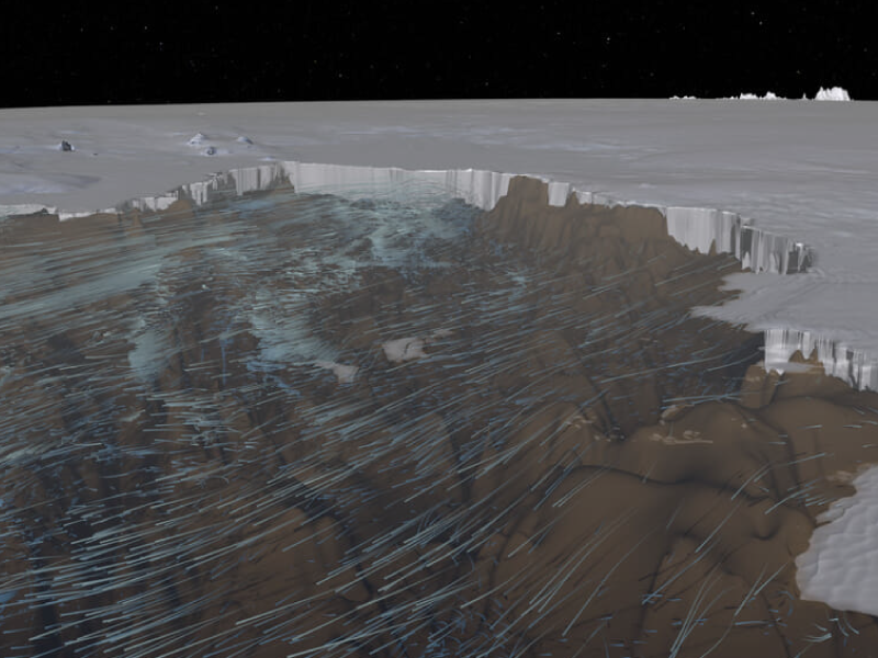
Ocean Flows Under the Pine Island Glacier, Antarctica
[05-Nov-2020] Glaciers surrounding the Amundsen Sea in Antarctica have been rapidly melting. As glaciers flow out from land to the ocean, large expanses of ice behind their leading edges float on the seawater. The point on a glacier where it first loses contact with land is called the grounding line. Nearly all glacier melt occurs on the underside of the glacier beyond the grounding line, on the section floating on seawater as the warmer ocean currents erode the base of the floating ice. This visualization shows the ocean currents in the Amundsen Sea derived from the "Estimating the Circulation and Climate of the Ocean" (ECCO) ocean circulation model. The visualization approaches the Pine Island Glacier, dives beneath the water and views the ocean flows circulating beneath the floating ice. The surface of the ice sheet is exaggerated by 4x while the topography below sea level is exaggerated by 15x for the purpose of clarity.Original Media » Click on the image to play the movie. Click on the Escape key or anywhere outside the shadowbox to close.
To download a copy, right click on the image and select Download Linked File (on a Mac keyboard, click the touchpad while holding down the Control key).